Sugar Land flood zones–Sugar Land is located near the Brazos river and has an elevation of 100ft, therefore, flooding is a potential hazard that needs to be understood. There are also many neighborhood lakes (and Oyster Creek) that run through Sugar Land and could serve as potential flood hazards. However, most of the Sugar Land neighborhoods, that could have potential flooding issues, are currently protected with a vast levee system.
Whenever you buy a home in Sugar Land you should obtain a recent survey and flood certificate to notify you if the home is in a Sugar Land high-risk flood zone or not. Most homes in Sugar Land do NOT require flood insurance because the flood hazard is considered very small. But if you have concerns, there is national flood insurance available at an extremely low cost ($400/yr) to most home owners.
As a service to all of my buying clients, I always research the FEMA flood maps to ensure that you know which Sugar Land flood zone (if any) a home is located in BEFORE you purchase. View a sample of my House Report.

 Source: http://www.sugarlandtx.gov/DocumentCenter/View/9144
I’m not a flood expert, weather expert, engineer, surveyor, etc…I’ve just lived on the Texas Gulf Coast for over 40 years and experienced many floods, hurricanes and tropical storms. Here’s my opinion based on what I have experienced…
 Pretty much all areas of the United States (and the world) have to deal with natural disasters. In California it’s earthquakes, mudslides, and wild fires. In the Midwest it’s tornadoes. In the Northeast it’s winter storms and blizzards. Many parts of the country deal with flooding…especially near rivers. Other parts deal with severe droughts. The fact is, you can’t completely avoid natural disasters anywhere…so you need to minimize your risk and prepare for them as best you can.
If you want to live anywhere on the Gulf Coast (Texas, Louisiana, Mississippi, Alabama, Florida) or anywhere in the Houston region, then you will need to be prepared for hurricanes and flash flooding. One thing history has shown us regarding flooding…history means nothing! Each time we experience a major flood, you will see many flooded home owners on the news saying something like, “We’ve lived here over 30 years and never flooded before.” Last year (2019) there was a major flash flood and the new thing we heard afterwards was, “We didn’t flood in Harvey, but we flooded this time.”
So just because a home has never flooded before, does NOT guarantee it will not flood in the future. It just means it has a lower risk for flooding. Likewise, just because a home flooded during Hurricane Harvey, does NOT mean it will ever flood again. That was a historical storm that, most experts believe, is unlikely to occur again in our lifetime.
NOTE: In my definition of “flooding” I am referring to your home being infiltrated with flood/surface water.
What Sugar Land Areas Flooded After Hurricane Harvey?
While flood zones are typically rated as 100-year or 500-year, Hurricane Harvey is being described as a an unprecedented, 1,000 year event (read more)! This means that homes that flooded during that once-in-a-life time weather event may never flood again. So let’s keep our wits about us. Investors (who are keeping their wits about them) are flocking to the area to buy homes that others won’t consider…because they know that a home that flooded during Harvey is not an indication of future flooding. In fact, less than 1 percent of Sugar Land homes were flooded during Hurricane Harvey…so don’t let what you see on t.v. give you the wrong impression…most of the homes in Sugar Land TX do not flood on a regular basis and did not flood even during this HISTORIC hurricane.
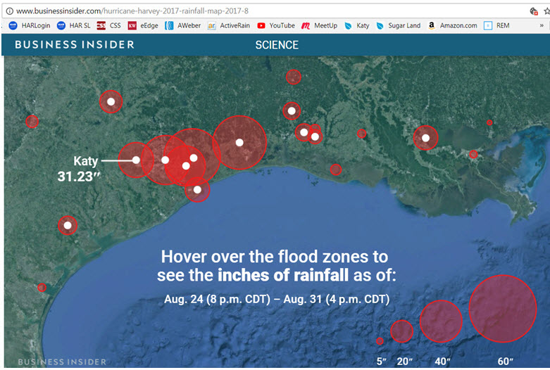
Source: http://www.businessinsider.com/hurricane-harvey-2017-rainfall-map-2017-8
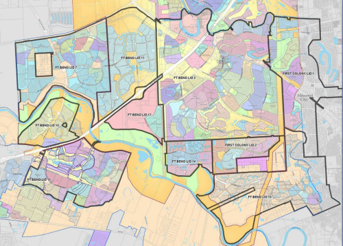
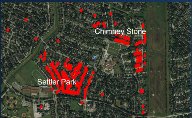
In Sugar Land there were approximately 230 homes in Fort Bend County LID #2 (map shown below) that flooded and 17 homes outside of LIDs. Knowing that LID #2 covers approximately 9,000 homes in First Colony, that means that only 2.5% of homes there flooded during this once-in-a-lifetime, historical rain event.
Sugar Land areas impacted by Hurricane Harvey:
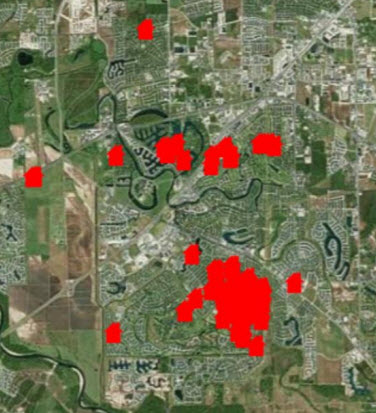
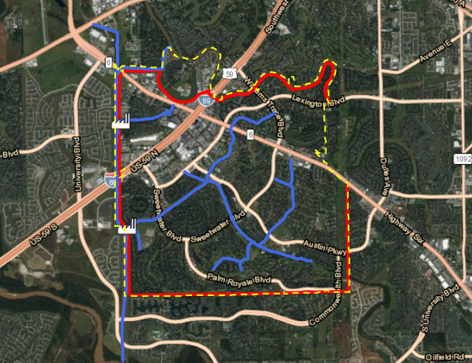
Riverstone
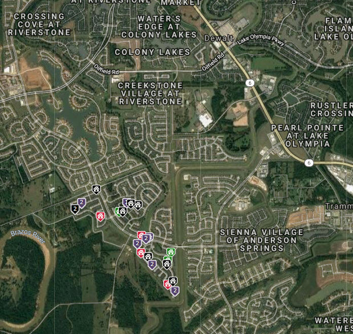
Hurricane Harvey affected a few homes the Riverstone Development. All the homes that are affected are in Levee Improvement District 19. The subdivision of Millwood at Riverstone had widespread flooding during Harvey and the residents have filed a lawsuit. So did the street of Falling Briar Lane in Riverstone. Other subdivisions in Riverstone that had a few flooded homes (but not widespread flooding!) include: Sweetbriar, The Orchard, Lost Creek and Shadow Glen…all of which are close to the Brazos river (see map below).
Sienna Plantation
According to reports, only about 65 of Sienna Plantation’s 7,700 houses flooded…less than 1 percent. It is difficult to determine exactly where the flooding occurred but it seems to be on the West side, closest to the Brazos River in Sienna Village of Waters Lake, and on the Southeast side in Sienna Point (new section).
⇒ Improvements Since Hurricane Harvey
Summary
Again…not all the homes in these neighborhoods flooded! The water got high and some of the roads were flooded for a few days, but this was an unprecedented weather event which is very unlikely to ever occur again.
With that in mind, I will say that it will be very important for home buyers to watch out for repaired homes and to make sure they have been repaired properly. And I will also say that there are areas in Houston that are prone to flooding, year after year, and you need to have a local Realtor who knows how to check the flood maps and filter out those areas from your search…like me!
And finally, as a resident of the Gulf Coast, you should know that hundreds of homes in the Houston area that are not in high-risk flood zones and had never flooded before during any other flood or hurricane event, did flood during Harvey. So that means…you never know for sure and you had better carry Flood Insurance on your home at all times! In my opinion, a $400/yr flood insurance policy is worth the peace of mind you have from knowing you won’t be financially devastated if a storm sits on top of your neighborhood and drops 50 inches of rain! I don’t know of any areas in the country that can handle that much water…do you?
Read also:
- Fort Bend County LID Map
- As Harvey Raged, Meteorologists Grasped for Words to Describe It
- NASA video shows Harvey’s 1,000-year flood event over Texas
Links and Resources
- Brazos River Information
- Emergency Notification System Sign Up
- Sugar Land Emergency Management’s Flood Safety Tips
- Read advice about flooding
- View digital Sugar Land flood map
- Learn more about flood zone definitions
- Read Q&A About Flood Insurance
REALTORS DON’T “JUST” SELL HOUSESReal estate agents don’t “just” sell houses; we sell a SERVICE to guide home buyers and sellers through the entire real estate transaction, which usually takes several months. We are more like real estate consultants than we are salespeople. That’s probably why 86 percent of all home buyers and sellers choose to hire a real estate agent when buying or selling a home! Buying or selling a home is not like buying or selling a TV, a computer, or a car. You can’t buy/sell a home in one day…even if the buyer is paying cash. There are MANY legal aspects, deadlines, and requirements that most people are not trained to handle. What’s more…mistakes along the way can cost you thousands and even hundreds of thousands of dollars. The financial risk is much greater than just about anything else you may buy.
Please read the list of my value-added services for home buyers |
FREE GUIDES & REPORTS
Click Image Below to Download a Guide or Report

![]()
View Helpful Videos on My YouTube Channel

Why You Should Hire Me
 Candid Advice—I promise to give you candid advice on all homes and areas so you can make the best decisions. I won’t ignore potential defects that can cost you money, or effect your resale value, in the future…I point them out to you! My job is to protect you from defective homes as much as possible while helping you make a sound financial investment. (Read client testimonials)
Local Area Expertise—This isn’t just my business…it’s where I work and live (for 20 years) so I really know the area. I will help you narrow your options and find the best neighborhood for you based on your specifications. For long-term resale value, the neighborhood you choose is just as important as the home you buy. (Download my Ultimate Sugar Land Guide)
Great Pricing Data—I will give you the most in-depth data you have ever seen…to help you make the wisest decisions. This includes a professional CMA when you are ready to purchase a specific home…so you don’t pay too much. (Also see Pricing a Home Correctly)
Premium Customized Home Searches—Yes, you can search on your own, but no other home search available can filter down to the school level…and filter out the subdivisions that may be known to flood. Tell me exactly what you want, and I can narrow down your options better than any search you have access to. (Request a Premium Customized Home Search)
Video Walkthroughs—If you or your spouse lives out of the state or country, then you will enjoy my detailed video walkthroughs. I have sold multiple homes to out-of-area clients “sight unseen” by providing High Definition video walkthroughs of potential homes. My videos show front and back yards, closets, pantries, laundry rooms, and the garage…as well as the entire home. This gives you a complete picture of the house (unlike those silly Matterports). I also point out any potential defects or deferred maintenance that I see. (view sample video walkthrough)
Easier Process—Moving your family (and possibly changing jobs) is stressful enough. I’m your transaction manager and will guide you, step-by-step, through the process so you never miss an important deadline. I assist with inspections, repair negotiations, home warranties, HOA compliance inspections, hazard insurance, surveys, appraisals, title commitment, home warranties, title company, and more. (Get Details of My Value-Added Services)
Connect With Sheila
[DISPLAY_ULTIMATE_SOCIAL_ICONS]